Blackdown Hills AONB, Devon
This is a circular walk along quiet single track country lanes. There are a few relatively short, steep climbs, but nothing too strenuous if you take it steady. There is a potential pub stop* a mile from home.
* We recommend checking pub opening times before you set off, as many pubs here have limited opening hours.
- Total distance 6 miles (9.6km)
- Estimated time 2hrs 50mins
- Elevation 232 ft at lowest point, 813 ft at highest point
- Total ascent 1537 ft
The route loops back through Stockland village, with a highly recommended pub stop at the Kings Arms just over a mile from home. For more information and contact details, check out our Local Pubs web page – we recommend you do this first as many pubs here have limited opening hours.
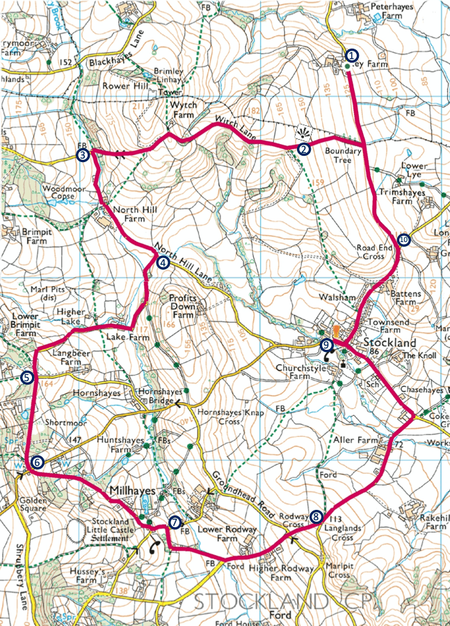
These instructions start at Ley Farm, Yarcombe, EX14 9LW, however you could also start it from The Kings Arms pub.
- Leave Ley Farm turning right out of the gate onto the lane (heading south). After a few minutes you’ll reach a lane heading up the valley to your right – take this lane (Witch Lane).
- At checkpoint 2 where the lane starts to flatten, on a clear day you should have a great view looking back across Ley Farm up the Yarty Valley with Yarcombe village to the north. Keep to this lane which crosses the top of the hill, passing a small farm on the right (Wytch Farm) before falling steeply to a junction.
- Turn left here along the lane with a brook running to the left. The lane bends through North Hill Farm, and after a few minutes you’ll reach a junction with a lane turning off to the right.
- Take this right turning. The lane will take a short rise then fall, passing through Lake Farm before a longer climb up the side of the valley. After the lane turns left it will start to level off and you’ll reach a lane turning off to the left.
- Ignore the left turning and keep to the lane which then falls and rises through a wooded area before reaching a crossroads.
- Here you have the option of cutting the route short by turning left and heading along the main road to Stockland (see map). Otherwise, head straight across the crossroads and follow the lane steeply downhill before winding through the hamlet of Millhayes. At the end of the lane (Millhayes junction) turn left, then soon after you’ll arrive at a junction with turning to the right.
- Take this right turn, and after the lane bends left you’ll head downhill crossing a small ford before rising again passing Higher Rodway Farm. At the top, head straight on at the crossroads (Rodway Cross) and shortly after you’ll reach another junction.
- Take a left turning here heading downhill, passing the turning into Rakehill Farm, then passing Aller Farm before a short rise to a road junction (Cokers Elm Cross). Turn left here, heading uphill toward Stockland village. After the road levels you’ll pass a small school (on your left), then Stockland village hall (on your right) before entering the village. When you get to the middle of the village you’ll see an old telephone box, and opposite, a right turning uphill which is the route back to Ley Farm. However, The Kings Arms Inn is straight on in case refreshments are in order.
- Once done at the Kings Arms Inn, head back to the junction in the middle of the village and take the turning uphill signposted towards Yarcombe and Chard (opposite the old telephone box). After passing Battens Farm the road will curve left before you see a left turning with a white thatched house on the opposite side of the road (Road End Cross).
- Take this left turn continuing uphill a short way. Keep to this lane, first passing the track down to Lower Lye, then passing the lane you originally took near the beginning of the walk, eventually arriving back at Ley Farm.

Leave a comment